
Ficheru:Empire of the Kökturks.png

Tamañu d'esta previsualización: 800 × 499 pixels. Otres resoluciones: 320 × 200 pixels | 640 × 399 pixels | 1024 × 638 pixels | 1280 × 798 pixels | 1745 × 1088 pixels.
Ficheru orixinal (1745 × 1088 píxels, tamañu de ficheru: 2,56 MB, triba MIME: image/png)
Resume
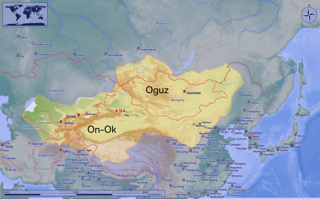
| Descripción | This map shows the kingdom of Kökturks after the division of the kingdom in 552. The grey area shows the area of On-Ok or the western Kökturks. The white area shows the area of the eastern Kökturk. This area was still in the sixth Century a Chinese protectorate. 745 the Kökturks were part of the Uyghur empire. After 840 Kökturks and the Uyghurs were conquered by the Kyrgyz. The source of this map: "Der große Atlas Weltgeschichte", Orbis Verlag 1990, ISBN 3-572-04755-2, P. 47 & 51 |
| Data | |
| Fonte | Trabayu propiu |
| Autor | Hardcore-Mike |
Llicencia
Yo, el titular de los drechos d'autor d'esta obra, la espublizo baxo la siguiente llicencia:
Este archivo se encuentra bajo la licencia Creative Commons Atribución 3.0 Unported.
- Ye llibre:
- pa compartir – pa copiar, distribuir y comunicar públicamente la obra
- pa remezclar – p'adautar la obra
- Baxo les condiciones siguientes:
- reconocimientu – Tienes de dar el créitu apropiáu, apurrir un enllaz a la llicencia ya indicar si realizasti dalgún cambéu. Puedes faelo de cualquier mou razonable ,pero non de manera que suxera l'encontu del autor pa ti o pal usu que faigas.
Historial del ficheru
Calca nuna fecha/hora pa ver el ficheru como taba daquella.
| Data/Hora | Miniatura | Dimensiones | Usuariu | Comentariu | |
|---|---|---|---|---|---|
| actual | 10:16 10 ago 2020 | | 1745 × 1088 (2,56 MB) | MicBy67 | Leichte Überarbeitung der Grenzverläufe, Änderung des westl. Teilreiches in "On-Ok" |
| 00:48 26 xnt 2020 |  | 1745 × 1088 (2,56 MB) | MicBy67 | Überarbeitung | |
| 19:59 1 pay 2012 |  | 1056 × 850 (1,17 MB) | MicBy67 | Map fault repaired | |
| 18:17 1 pay 2012 |  | 1056 × 850 (1,17 MB) | MicBy67 | {{Information |Description=This map shows the kingdom of Kökturks after the division of the kingdom in 552. The grey area shows the area of On-Ok or the western Kökturks. The white area shows the area of the eastern Kökturk. This area was still in t... |
Usu del ficheru
La páxina siguiente usa esti ficheru:
Usu global del ficheru
Estes otres wikis usen esti ficheru:
- Usu en cs.wikipedia.org
- Usu en de.wikipedia.org
- Usu en en.wikipedia.org
- Usu en es.wikipedia.org
- Usu en fr.wikipedia.org
- Usu en mn.wikipedia.org
- Usu en pnb.wikipedia.org
- Usu en sl.wikipedia.org
- Usu en zh.wikipedia.org