Ficheru:Empire of Theodoric the Great 523.gif

Contenido de la página no disponible en otros idiomas.
De Wikipedia

Empire_of_Theodoric_the_Great_523.gif(523 × 478 píxels, tamañu de ficheru: 33 kB, triba MIME: image/gif)

Esti ficheru ye de Wikimedia Commons y puen usalu otros proyeutos. La descripción de la páxina de descripción del ficheru s'amuesa darréu.

Resume

Descripción
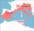
English: Map of the territories (pink) ruled by Theodoric the Great at their height in 523, when he annexed the southern part of the Burgundian kingdom, between the rivers Durance and Isere. Stippled areas indicate other kingdoms dominated by Theodoric at this time.
Data
Fonte prepared from information in Wikipedia, Historical Atlases, and other books,in particular The Goths by Peter Heather
Autor Howard Wiseman
Otres versiones based on a map at http://www.sci.gu.edu.au/~wiseman/Roman/5CompMaps.html

Llicencia

Vortimer de Wikipedia en inglés, titular de los drechos d'autor d'esta obra, la espubliza baxo les siguientes llicencies:
GNU head Autorízase la copia, distribución y/o cambéu d'esti documentu baxo los términos de la Llicencia de documentación llibre GNU, versión 1.2 o cualesquier otra que nel futuru espublice la Free Software Foundation; ensin seiciones invariables, testos de portada, nin testos de contraportada. S'inclúi una copia de la llicencia na seición titulada GNU Free Documentation License.
w:es:Creative Commons
reconocimientu
Este archivo se encuentra bajo la licencia Creative Commons Atribución 3.0 Unported.
Reconocimientu: Vortimer de Wikipedia en inglés
Ye llibre:
  • pa compartir – pa copiar, distribuir y comunicar públicamente la obra
  • pa remezclar – p'adautar la obra
Baxo les condiciones siguientes:
  • reconocimientu – Tienes de dar el créitu apropiáu, apurrir un enllaz a la llicencia ya indicar si realizasti dalgún cambéu. Puedes faelo de cualquier mou razonable ,pero non de manera que suxera l'encontu del autor pa ti o pal usu que faigas.
Pues seleicionar la llicencia que prefieras.

Rexistru de xubíes orixinal

Transferred from en.wikipedia to Commons by Lazyhawk using CommonsHelper.

The original description page was here. All following user names refer to en.wikipedia.
  • 2007-12-28 04:23 Vortimer 523×478× (33298 bytes) {{Information |Description=Map of the territories (pink) ruled by Theodoric the Great at their height in 523, when he annexed the souther part of the Burgundian kingdom, between the rivers Durance and Isere. Stippled areas indicate other kin
  • 2007-12-27 12:01 Vortimer 523×478× (33484 bytes) {{Information |Description=Map of the territories (pink) ruled by Theodoric the Great at their height in 523, when he annexed the souther part of the Burgundian kingdom, between the rivers Durance and Isere. Stippled areas indicate other kingdoms dominate
  • 2007-12-27 11:57 Vortimer 523×478× (32320 bytes) {{Information |Description=Map of the territories (pink) ruled by Theodoric the Great at their height in 523, when he annexed the souther part of the Burgundian kingdom, between the rivers Durance and Isere. Stippled areas indicate other kingdoms dominate

Pies

Añade una explicación corta acerca de lo que representa este archivo

Elementos representados en este archivo

representa a

Historial del ficheru

Calca nuna fecha/hora pa ver el ficheru como taba daquella.

Data/HoraMiniaturaDimensionesUsuariuComentariu
actual13:15 20 avi 2011Miniatura de la versión a fecha de 13:15 20 avi 2011523 × 478 (33 kB)OgreBot(BOT): Reverting to most recent version before archival
13:15 20 avi 2011Miniatura de la versión a fecha de 13:15 20 avi 2011523 × 478 (33 kB)OgreBot(BOT): Uploading old version of file from en.wikipedia; originally uploaded on 2007-12-27 12:01:51 by Vortimer
13:15 20 avi 2011Miniatura de la versión a fecha de 13:15 20 avi 2011523 × 478 (32 kB)OgreBot(BOT): Uploading old version of file from en.wikipedia; originally uploaded on 2007-12-27 11:57:01 by Vortimer
01:55 12 set 2011Miniatura de la versión a fecha de 01:55 12 set 2011523 × 478 (33 kB)File Upload Bot (Magnus Manske) {{BotMoveToCommons|en.wikipedia|year={{subst:CURRENTYEAR}}|month={{subst:CURRENTMONTHNAME}}|day={{subst:CURRENTDAY}}}} {{Information |Description={{en|Map of the territories (pink) ruled by Theodoric the Great at their height in 523, when he annexed the

Les páxines siguientes usen esti ficheru:

Usu global del ficheru

Estes otres wikis usen esti ficheru: