
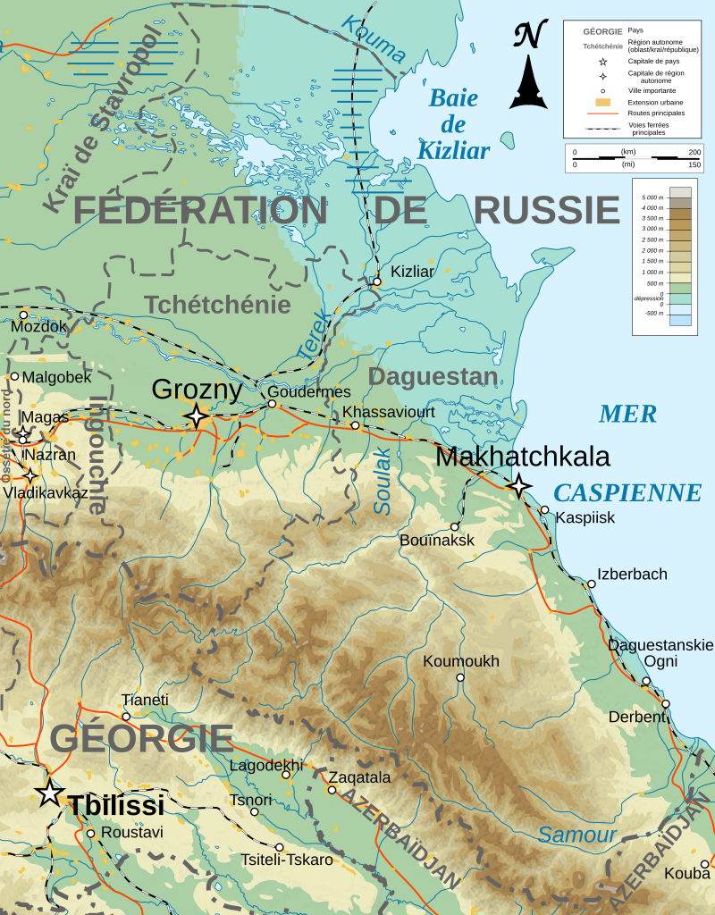
Ficheru:Dagestan topographic map-fr.svg

Tamañu de la vista previa PNG d'esti ficheru SVG: 400 × 512 pixels. Otres resoluciones: 187 × 240 pixels | 375 × 480 pixels | 600 × 768 pixels | 800 × 1024 pixels | 1600 × 2048 pixels.
Ficheru orixinal (ficheru SVG, 400 × 512 píxels nominales, tamañu de ficheru: 3,27 MB)
Resume
| Descripción |
[] |
| Data | |
| Fonte |
English: Own work ; Topographic data from the NASA Shuttle Radar Topography Mission (SRTM3 v.2) (public domain) edited with 3DEM, reprojected in UTM with GDAL (GDAL), and vectorized with Inkscape ; UTM projection ; WGS84 datum ; shaded relief (composite image of N-W, W and N lightning positions) ; Reference used for the additional data : * Rivers, cities, railroads, routes, bathymetry : Demis add-on for World Wind (see the approval e-mail and the Demis forum) ; * Borders and coast : World data bank II ; Approximate scale of topographic data : 1:1,463,000 ; Note : The shaded relief is a raster image embedded in the SVG file. Français : Création personnelle ; Données topographiques de la NASA Shuttle Radar Topography Mission (SRTM3 v.2) (domaine public) éditées avec 3DEM, reprojetées en UTM avec GDAL et vectorisées avec Inkscape ; projection UTM ; WGS84 datum ; relief ombré (image composite d'éclairages du N-O, O et N) ; Références utilisées pour les données complémentaires : * Rivières, villes, chemins de fers, routes, bathymétrie : Demis add-on for World Wind (cf. l'e-mail d'approbation de Demis et le Demis forum) ; * Frontières et côtes : World data bank II ; Échelle approximative des données topographiques : 1:1 463 000 ; Note : Le relief ombré est une image bitmap embarquée dans le fichier SVG. |
| Autor | Bourrichon - fr:Bourrichon) |
| Otres versiones |
[]
|


|
Esti ficheru SVG tien testu integráu que pue traducise fácilmente a la to llingua usando un editor de SVG como Inkscape o Adobe Illustrator. Ver más. Tamién pues descargalu y traducilu de mou manual usando un editor de testu. |
English: This image was selected as a picture of the day on the Ossetian Wikipedia for 18th of November 2009.
|
Llicencia
Yo, el titular de los drechos d'autor d'esta obra, la espublizo baxo les siguientes llicencies:

|
Autorízase la copia, distribución y/o cambéu d'esti documentu baxo los términos de la Llicencia de documentación llibre GNU, versión 1.2 o cualesquier otra que nel futuru espublice la Free Software Foundation; ensin seiciones invariables, testos de portada, nin testos de contraportada. S'inclúi una copia de la llicencia na seición titulada GNU Free Documentation License. |
This file is licensed under the Creative Commons Attribution-Share Alike 4.0 International, 3.0 Unported, 2.5 Generic, 2.0 Generic and 1.0 Generic license.
- Ye llibre:
- pa compartir – pa copiar, distribuir y comunicar públicamente la obra
- pa remezclar – p'adautar la obra
- Baxo les condiciones siguientes:
- reconocimientu – Tienes de dar el créitu apropiáu, apurrir un enllaz a la llicencia ya indicar si realizasti dalgún cambéu. Puedes faelo de cualquier mou razonable ,pero non de manera que suxera l'encontu del autor pa ti o pal usu que faigas.
- compartir igual – Si entemeces, tresformes o te bases nesti material, tienes de distribuir les tos contribuciones baxo la mesma llicencia o una compatible cola orixinal.
Pues seleicionar la llicencia que prefieras.
Historial del ficheru
Calca nuna fecha/hora pa ver el ficheru como taba daquella.
| Data/Hora | Miniatura | Dimensiones | Usuariu | Comentariu | |
|---|---|---|---|---|---|
| actual | 00:08 15 feb 2023 | | 400 × 512 (3,27 MB) | Takhirgeran Umar | Reverted to version as of 21:19, 13 January 2020 (UTC) |
| 01:45 1 feb 2023 |  | 400 × 512 (3,27 MB) | Niyskho | Reverted to version as of 16:57, 13 November 2008 (UTC) | |
| 21:19 13 xin 2020 |  | 400 × 512 (3,27 MB) | Takhirgeran Umar | Clarification | |
| 16:57 13 pay 2008 |  | 400 × 512 (3,27 MB) | Bourrichon | retrait bathy inutile | |
| 17:23 9 pay 2008 |  | 400 × 512 (3,28 MB) | Bourrichon | ||
| 16:24 8 pay 2008 |  | 400 × 512 (3,27 MB) | Bourrichon | == Summary == {{Information |Description={{de|Topographische Karte von Kaukasien, französische Version}}{{en|Topographic map in French of Caucasus}}{{fr|Carte topographique en français du Caucase}} |Sou |
Usu del ficheru
Nun hai páxines qu'usen esti ficheru.
Usu global del ficheru
Estes otres wikis usen esti ficheru:
- Usu en fi.wikipedia.org
- Usu en fr.wikipedia.org
- Usu en no.wikipedia.org
- Usu en os.wikipedia.org