
Ficheru:Canada provinces 1905-1912.png
Tamañu d'esta previsualización: 694 × 600 pixels. Otres resoluciones: 278 × 240 pixels | 556 × 480 pixels | 1000 × 864 pixels.
Ficheru orixinal (1000 × 864 píxels, tamañu de ficheru: 63 kB, triba MIME: image/png)
Resume
| Descripción |
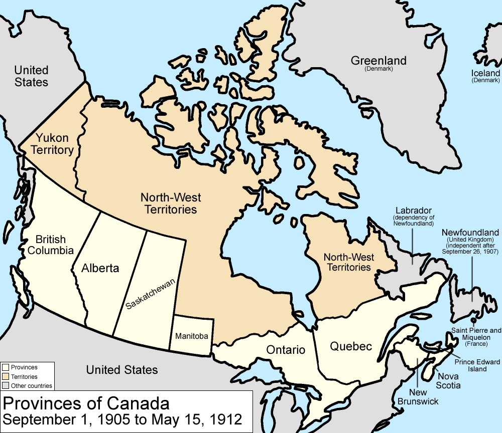
Map of the provinces and territories of Canada as they were between 1905 and 1912. On September 1 1905, Alberta and Saskatchewan were created from parts of the North-West Territories and the District of Keewatin; the remainder of the District of Keewatin was remerged into the North-West Territories. On May 15 1912, parts of the North-West Territories were given to Manitoba, Ontario, and Quebec. Also note that in 1912, the official name dropped the hyphen, changing to "Northwest Territories". Made by User:Golbez. |
| Data | 13 de febreru de 2006 (fecha original de carga) |
| Fonte | No machine-readable source provided. Own work assumed (based on copyright claims). |
| Autor | No machine-readable author provided. Golbez assumed (based on copyright claims). |
Llicencia
Yo, el titular de los drechos d'autor d'esta obra, la espublizo baxo les siguientes llicencies:

|
Autorízase la copia, distribución y/o cambéu d'esti documentu baxo los términos de la Llicencia de documentación llibre GNU, versión 1.2 o cualesquier otra que nel futuru espublice la Free Software Foundation; ensin seiciones invariables, testos de portada, nin testos de contraportada. S'inclúi una copia de la llicencia na seición titulada GNU Free Documentation License. |
| Esti ficheru ta disponible baxo la llicencia Creative Commons Reconocimientu-Compartir igual 3.0 xenérica. | ||
| ||
| Esta etiqueta de llicencia s'amestó a esti ficheru como parte del anovamientu de la llicencia GFDL. |
Este archivo está disponible bajo la licencia Creative Commons Reconocimiento 2.5 Genérica.
- Ye llibre:
- pa compartir – pa copiar, distribuir y comunicar públicamente la obra
- pa remezclar – p'adautar la obra
- Baxo les condiciones siguientes:
- reconocimientu – Tienes de dar el créitu apropiáu, apurrir un enllaz a la llicencia ya indicar si realizasti dalgún cambéu. Puedes faelo de cualquier mou razonable ,pero non de manera que suxera l'encontu del autor pa ti o pal usu que faigas.
Pues seleicionar la llicencia que prefieras.
Historial del ficheru
Calca nuna fecha/hora pa ver el ficheru como taba daquella.
| Data/Hora | Miniatura | Dimensiones | Usuariu | Comentariu | |
|---|---|---|---|---|---|
| actual | 17:22 14 xnt 2009 | | 1000 × 864 (63 kB) | Golbez | New color scheme, other borders |
| 09:59 7 ago 2006 |  | 1000 × 864 (50 kB) | Golbez | with legend | |
| 02:24 18 feb 2006 |  | 1000 × 864 (49 kB) | Golbez | Better version | |
| 23:49 13 feb 2006 |  | 1000 × 864 (43 kB) | Golbez | better colors | |
| 07:14 13 feb 2006 |  | 1000 × 864 (42 kB) | Golbez | Map of the provinces and territories of Canada as they were between 1905 and 1912. On September 1 1905, Alberta and Saskatchewan were created from parts of the North-West Territories. On May 15 1912, parts of the North-West Territories were given to Manit |
Usu del ficheru
La páxina siguiente usa esti ficheru:
Usu global del ficheru
Estes otres wikis usen esti ficheru:
- Usu en arz.wikipedia.org
- Usu en de.wikipedia.org
- Usu en en.wikipedia.org
- Usu en es.wikipedia.org
- Usu en fr.wikipedia.org
- Usu en fy.wikipedia.org
- Usu en gl.wikipedia.org
- Usu en it.wikipedia.org
- Usu en no.wikipedia.org
- Usu en pt.wikipedia.org
- Usu en ru.wikipedia.org
- Usu en sv.wikipedia.org
- Usu en uk.wikipedia.org
- Usu en vi.wikipedia.org
- Usu en www.wikidata.org
- Usu en zh.wikipedia.org