
Ficheru:British Columbia-map.png
Nun ta disponible con mayor resolución.
British_Columbia-map.png (280 × 230 píxels, tamañu de ficheru: 14 kB, triba MIME: image/png)

|
File:British Columbia, Canada.svg es una versión vectorial de este archivo. Debería usarse esa versión en lugar de este archivo PNG, cuando sea mejor.
File:British Columbia-map.png → File:British Columbia, Canada.svg
Para más información, lee Ayuda:SVG. |
 |
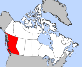
Map of British Columbia
Projection: Lambert azimuthal equal-area
Geospatial data from: The Atlas of Canada, The National Atlas of the United States archive copy at the Wayback Machine and U.S. Geological Survey
Cartographer: John Fowler
| Yo, el titular de los drechos d'autor d'esta obra, la llibero como dominiu públicu. Esto s'aplica nel mundu ensembre. En dellos países seique esto nun seya posible llegalmente; nesti casu: Doi a cualesquier persona permisu pa usar esta obra pa cualesquier propósitu, ensin denguna condición, menos si eses condiciones requierense pola llei. |
Historial del ficheru
Calca nuna fecha/hora pa ver el ficheru como taba daquella.
| Data/Hora | Miniatura | Dimensiones | Usuariu | Comentariu | |
|---|---|---|---|---|---|
| actual | 12:12 24 mar 2005 | | 280 × 230 (14 kB) | Voyager | Map of British Columbia Projection: Lambert azimuthal equal-area Geospatial data from: [http://atlas.gc.ca/ The Atlas of Canada], [http://www.nationalatlas.gov/ The National Atlas of the United States] and [http://www.usgs.gov U.S. Geological Survey] C |
Usu del ficheru
Nun hai páxines qu'usen esti ficheru.
Usu global del ficheru
Estes otres wikis usen esti ficheru:
- Usu en fr.wikipedia.org
- Usu en he.wikivoyage.org