Ficheru:Breakup of Yugoslavia.gif
Contenido de la página no disponible en otros idiomas.
De Wikipedia

Ficheru orixinal(1545 × 1242 píxels, tamañu de ficheru: 187 kB, triba MIME: image/gif, animáu, 14 cuadros, 44s)

Esti ficheru ye de Wikimedia Commons y puen usalu otros proyeutos. La descripción de la páxina de descripción del ficheru s'amuesa darréu.

Esta imagen volverse a crear usando gráficos vectoriales como un archivo SVG. Esto proporciona muchas ventajas, véase Commons:Media for cleanup (en inglés) para más información. Si ya hay una versión SVG de esta imagen disponible, por favor súbala a Commons. Tras subirla, reemplace esta plantilla con la plantilla {{vector version available|nuevo nombre de imagen.svg}} en esta imagen. Se recomienda nombrar el archivo SVG "Breakup of Yugoslavia.svg" - entonces la plantilla Vector version available (o Vva) no necesita el parámetro nuevo nombre de imagen.

Resume

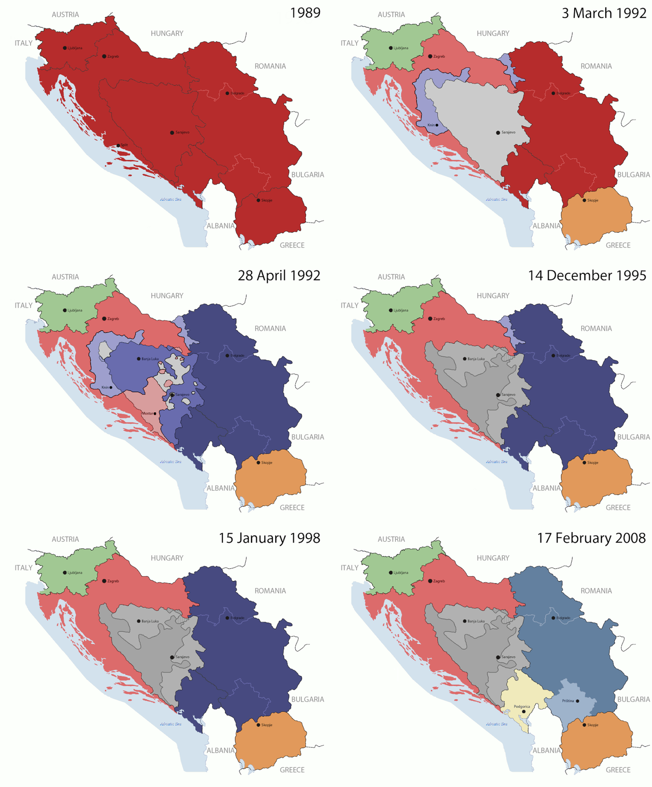
Key:

Yugoslavia (1943–1992) SFR Yugoslavia
Croatia (1991–present) Croatia
Herzeg-Bosnia (1992–1994)
UNTAES (1996–1998)
Federal Republic of Yugoslavia / Serbia and Montenegro (1992–2006) Serbia and Montenegro
Republika Srpska (1992–present) Republika Srpska
Serbian Krajina (1991–1995/96)
Republic of Bosnia and Herzegovina (1992–1995)
Bosnia and Herzegovina (1998–present) Bosnia and Herzegovina
Western Bosnia (1993–1995)
Serbia (2006–present) Serbia
Kosovo (under UNMIK control 1999–present; declaration of independence 2008) Kosovo
Montenegro (2006–present) Montenegro
Macedonia (1991–present) Macedonia
Slovenia (1991–present) Slovenia


Descripción

This is an animated GIF that shows the stages of the breakup of the SFR Yugoslavia in the 90's and 2000's. The map based off Morwen's map of the divisions of the SFRY, Which is licensed by the GFDL. The source for the dates of independence is the CIA World Factbook. These maps do not now show the Inter-Entity Boundary Line (IEBL) and/or the entities that are separated by it. The IEBL has been drawn based on this CIA map; the Brčko District has been drawn based on Image:BH municipality location.gif, by user:Ante Perkovic. I might add them in the future.

Since the original map was GFDL, this image is as well.

A map depicting Kosovo's final status is ready once it takes effect.


Changelog for versions 2/3:

Here are some changes in this new build of the map:

  • The Kosovo boundary has been given a shade of red instead of the previous UN blue since they are a province of Serbia under UNIMIK control.
  • Montenegro's color has been changed to a golden shade close to what's on the flag.
  • The IEBL and the Brčko District has been redrawn because I deleted the original map; the color for the Republika Srpska is lighter.
  • The dates are at the top left hand corner of the map instead of the bottom.
  • I have taken a new approach as to the boundaries. Each part of Yugoslavia now shows the boundary on the maps starting the year they broke away. I feel this change helps readers understand the breakup better.
  • The SFRY and the FRY are in different shades since the FRY was never accepted as the successor to the former by the UN.
  • The colors for the entities of BiH have been removed as to not confuse people into thinking that they are independent states. What remains is the IEBL with both entities in green.
  • The Kosovo boundary is finally in hash marks!
  • The Brčko District has been removed. The sale is too small to show accurately.

Changelog for version 4:

  • The map is larger!
  • The image has been rebuilt to include the eastern part of FYR Macedonia.
  • The image has been updated to take in Kosovo's new status.
  • The IEBL is now a darker line.
  • Montenegro, Kosovo, and FRY/SCG/Serbia have new colors!

Changelog for version 5:

  • Rebuilt
  • Larger map: size of base image
  • Accurate Inter-Entity Boundary Line
Data 24 July 2006 (orginal upload date)
Fonte Made by Hoshie; see above for more details on sources.
Autor Hoshie
Otres versiones

Llicencia

GNU head Autorízase la copia, distribución y/o cambéu d'esti documentu baxo los términos de la Llicencia de documentación llibre GNU, versión 1.2 o cualesquier otra que nel futuru espublice la Free Software Foundation; ensin seiciones invariables, testos de portada, nin testos de contraportada. S'inclúi una copia de la llicencia na seición titulada GNU Free Documentation License.
w:es:Creative Commons
reconocimientu compartir igual
Esti ficheru ta disponible baxo la llicencia Creative Commons Reconocimientu-Compartir igual 3.0 xenérica.
Ye llibre:
  • pa compartir – pa copiar, distribuir y comunicar públicamente la obra
  • pa remezclar – p'adautar la obra
Baxo les condiciones siguientes:
  • reconocimientu – Tienes de dar el créitu apropiáu, apurrir un enllaz a la llicencia ya indicar si realizasti dalgún cambéu. Puedes faelo de cualquier mou razonable ,pero non de manera que suxera l'encontu del autor pa ti o pal usu que faigas.
  • compartir igual – Si entemeces, tresformes o te bases nesti material, tienes de distribuir les tos contribuciones baxo la mesma llicencia o una compatible cola orixinal.
Esta etiqueta de llicencia s'amestó a esti ficheru como parte del anovamientu de la llicencia GFDL.

Pies

Añade una explicación corta acerca de lo que representa este archivo

Elementos representados en este archivo

representa a

tipo de archivo español

image/gif

05ca2aefea8406b809968643552d5095c847a42f

191 625 Byte

44 segundu

1242 píxel

1545 píxel

Historial del ficheru

Calca nuna fecha/hora pa ver el ficheru como taba daquella.

(lo más nuevo | lo más antiguo) Ver (10 siguientes | ) (10 | 20 | 50 | 100 | 250 | 500)
Data/HoraMiniaturaDimensionesUsuariuComentariu
actual07:40 17 xnt 2016Miniatura de la versión a fecha de 07:40 17 xnt 20161545 × 1242 (187 kB)מפתח-רשימהReverted to version as of 17:22, 21 August 2015 (UTC)
17:22 21 ago 2015Miniatura de la versión a fecha de 17:22 21 ago 20151463 × 1158 (1,81 MB)BraganzaReverted to version as of 03:57, 19 January 2010
17:22 21 ago 2015Miniatura de la versión a fecha de 17:22 21 ago 20151545 × 1242 (187 kB)BraganzaReverted to version as of 01:02, 19 December 2011
17:15 21 ago 2015Miniatura de la versión a fecha de 17:15 21 ago 2015120 × 95 (3 kB)Braganza03:57, 19. Jan. 2010
01:02 19 avi 2011Miniatura de la versión a fecha de 01:02 19 avi 20111545 × 1242 (187 kB)DIREKTORAdded details
18:09 27 xnt 2011Miniatura de la versión a fecha de 18:09 27 xnt 20111545 × 1242 (170 kB)DIREKTORSmall fixes
17:28 27 xnt 2011Miniatura de la versión a fecha de 17:28 27 xnt 20111545 × 1242 (171 kB)DIREKTORAdded UNMIK
16:38 27 xnt 2011Miniatura de la versión a fecha de 16:38 27 xnt 20111545 × 1242 (165 kB)DIREKTORDates for the last two frames.
12:10 27 xnt 2011Miniatura de la versión a fecha de 12:10 27 xnt 20111545 × 1242 (149 kB)DIREKTORLighter shade for country names
16:59 26 xnt 2011Miniatura de la versión a fecha de 16:59 26 xnt 20111545 × 1242 (170 kB)DIREKTORHigher res plus details
(lo más nuevo | lo más antiguo) Ver (10 siguientes | ) (10 | 20 | 50 | 100 | 250 | 500)

La páxina siguiente usa esti ficheru:

Usu global del ficheru

Estes otres wikis usen esti ficheru:

Ver más usos globales d'esti ficheru.

Metadatos