
Ficheru:Boko Haram insurgency map.png

Tamañu d'esta previsualización: 779 × 599 pixels. Otres resoluciones: 312 × 240 pixels | 624 × 480 pixels | 998 × 768 pixels | 1280 × 985 pixels | 1600 × 1231 pixels.
Ficheru orixinal (1600 × 1231 píxels, tamañu de ficheru: 395 kB, triba MIME: image/png)
Resume

|
File:Boko Haram insurgency map.svg es una versión vectorial de este archivo. Debería usarse esa versión en lugar de este archivo PNG.
File:Boko Haram insurgency map.png → File:Boko Haram insurgency map.svg
Para más información, lee Ayuda:SVG. |
 |
| Descripción |
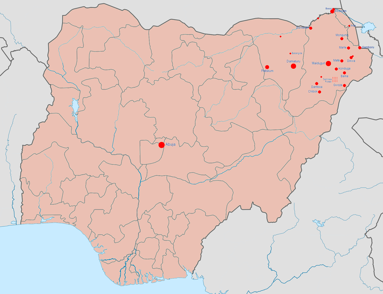
English: Map of the Boko Haram insurgency. The map image is based on Template:Nigerian insurgency detailed map.
Controlled by the Nigerian government
Controlled by Boko Haram/the Islamic State of Iraq and the Levant (variously called ISIL, ISIS, IS, Daesh) |
| Data | |
| Fonte | Trabayu propiu |
| Autor | BlueHypercane761 |
Llicencia
Yo, el titular de los drechos d'autor d'esta obra, la espublizo baxo la siguiente llicencia:
Este archivo está disponible bajo la licencia Creative Commons Attribution-Share Alike 4.0 International.
- Ye llibre:
- pa compartir – pa copiar, distribuir y comunicar públicamente la obra
- pa remezclar – p'adautar la obra
- Baxo les condiciones siguientes:
- reconocimientu – Tienes de dar el créitu apropiáu, apurrir un enllaz a la llicencia ya indicar si realizasti dalgún cambéu. Puedes faelo de cualquier mou razonable ,pero non de manera que suxera l'encontu del autor pa ti o pal usu que faigas.
- compartir igual – Si entemeces, tresformes o te bases nesti material, tienes de distribuir les tos contribuciones baxo la mesma llicencia o una compatible cola orixinal.
Historial del ficheru
Calca nuna fecha/hora pa ver el ficheru como taba daquella.
| Data/Hora | Miniatura | Dimensiones | Usuariu | Comentariu | |
|---|---|---|---|---|---|
| actual | 07:08 23 xin 2017 | | 1600 × 1231 (395 kB) | BlueHypercane761 | 1-22-2017 Update. The Nigerian Army and its allies finally annihilated Boko Haram in its last camp in Sambisa Forest (its last known stronghold), on December 24, 2016, reducing Boko Haram to a weakened, insurgent group. |
| 23:41 6 xnt 2016 |  | 1600 × 1231 (395 kB) | BlueHypercane761 | 7-6-2016 Update. The Nigerian Army and the Chadian Army completely sealed off the Sambisa Forest region on June 9, 2016, and have captured 50% of the forest. | |
| 22:09 25 avi 2015 |  | 1600 × 1231 (395 kB) | BlueHypercane761 | 12-25-2015 Update. The Nigerian Army has pushed into the heart of Sambisa Forest. | |
| 06:43 12 pay 2015 |  | 1600 × 1231 (395 kB) | BlueHypercane761 | Update for 11-12-2015. Boko Haram's territorial control was reduced to Sambisa Forest on Septemebr 8, 2015. The situation is current as of November 12, 2015. | |
| 06:28 12 pay 2015 |  | 1600 × 1231 (395 kB) | BlueHypercane761 | User created page with UploadWizard |
Usu del ficheru
Nun hai páxines qu'usen esti ficheru.
Usu global del ficheru
Estes otres wikis usen esti ficheru:
- Usu en en.wikipedia.org
- Usu en es.wikipedia.org
- Usu en ga.wikipedia.org
- Usu en id.wikipedia.org
- Usu en ko.wikipedia.org