
Ficheru:B26055943A - A map of the East-Indies and the adjacent countries.jpg

Tamañu d'esta previsualización: 800 × 509 pixels. Otres resoluciones: 320 × 204 pixels | 640 × 407 pixels | 1024 × 652 pixels | 1280 × 815 pixels | 2560 × 1629 pixels | 7509 × 4779 pixels.
Ficheru orixinal (7509 × 4779 píxels, tamañu de ficheru: 12,73 MB, triba MIME: image/jpeg)
Resume
| Descripción |
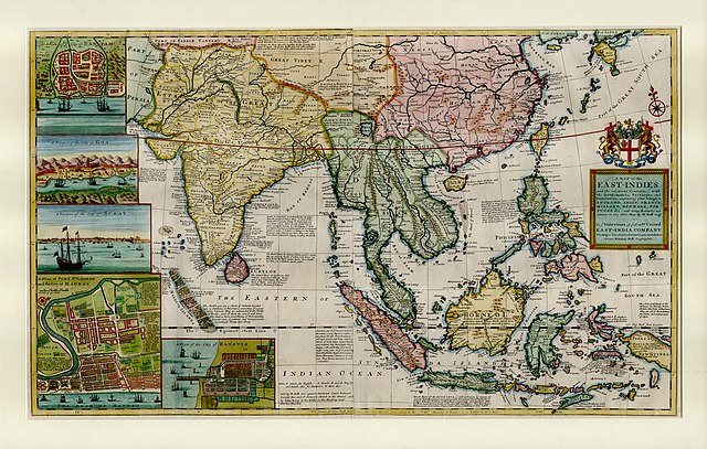
English: This large map by Herman Moll shows the East Indies from the Persian border to New Guinea and the southern part of Japan, including India, Ceylon, southeast Asia, most of China, Indonesia and the Philippines. It illustrates the extent of European influence and trade in the region, at the height of European colonial control. Further map features and detail maps of interest: Batavia, Goa, Mughal Empire, Maldives, Chennai, Banten, Lake Chimay |
| Data | |
| Fonte | NLB Singapore, David Parry Southeast Asian Map Collection. Available on BookSG https://eresources.nlb.gov.sg/printheritage/detail/3957ca10-8863-4f87-9d8c-49cfe590b0cd.aspx |
| Autor | Moll, Herman, -1732 |
| Otres versiones |


Llicencia
| Esti ficheru ta disponible baxo la llicencia Creative Commons de Dedicatoria universal al dominiu públicu CC0 1.0. | |
| La persona qu'asoció una obra con esti documentu dedicó esa obra al dominiu públicu per aciu de la cesión mundial de los sos drechos baxo les lleis de drechos d'autor, incluyendo tolos los drechos llegales rellacionaos y axacentes, dientro del ámbitu permitíu pola llei. Pue copiar, camudar, distribuir y reproducir la obra, incluyendo con oxetivos comerciales, ensin pidir permisu.
|
Historial del ficheru
Calca nuna fecha/hora pa ver el ficheru como taba daquella.
| Data/Hora | Miniatura | Dimensiones | Usuariu | Comentariu | |
|---|---|---|---|---|---|
| actual | 05:13 28 avi 2021 | | 7509 × 4779 (12,73 MB) | NLSingapore | Uploaded a work by Moll, Herman, -1732 from NLB Singapore, David Parry Southeast Asian Map Collection. Available on BookSG https://eresources.nlb.gov.sg/printheritage/detail/3957ca10-8863-4f87-9d8c-49cfe590b0cd.aspx with UploadWizard |
Usu del ficheru
La páxina siguiente usa esti ficheru:
Usu global del ficheru
Estes otres wikis usen esti ficheru:
- Usu en ar.wikipedia.org
- Usu en az.wikipedia.org
- Usu en be.wikipedia.org
- Usu en bg.wikipedia.org
- Usu en br.wikipedia.org
- Usu en ca.wikipedia.org
- Usu en cy.wikipedia.org
- Usu en el.wikipedia.org
- Usu en eo.wikipedia.org
- Usu en eu.wikipedia.org
- Usu en fr.wikipedia.org
- Usu en ga.wikipedia.org
- Usu en he.wikipedia.org
- Usu en hy.wikipedia.org
- Usu en it.wikipedia.org
- Usu en uk.wikipedia.org
- Usu en www.wikidata.org