
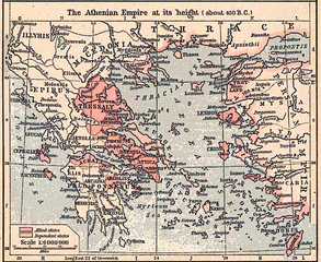
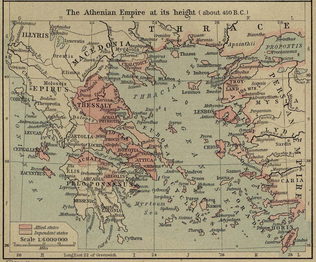
Ficheru:Athenian empire atheight 450 shepherd1923.png

Tamañu d'esta previsualización: 733 × 600 pixels. Otres resoluciones: 293 × 240 pixels | 587 × 480 pixels | 939 × 768 pixels | 1094 × 895 pixels.
Ficheru orixinal (1094 × 895 píxels, tamañu de ficheru: 2,02 MB, triba MIME: image/png)
Resume
| Descripción |
Scan from "Historical Atlas" by William R. Shepherd, New York, Henry Holt and Company, 1926 ed. Original image at the Perry-Castañeda Library Map Collection at the en:University of Texas at Austin website: http://www.lib.utexas.edu/maps/historical/shepherd/athenian_empire_450.jpg From the FAQ @ http://www.lib.utexas.edu/maps/faq.html
This map is not so marked. en:Category:Historical maps by William R. Shepherd |
| Fonte | William R. Shepherd |
| Autor | William R. Shepherd |
Llicencia
Este archivo se encuentra en el dominio público en los Estados Unidos porque fue publicado en ese país entre los años 1929 y 1977 (ambos incluidos) sin haber indicado un aviso de derechos de autor. A menos que su autor haya fallecido años antes, se mantiene bajo propiedad intelectual en los países o zonas que no aplican la regla del plazo más corto para las obras estadounidenses, como Canadá (50 años p.m.a.), China continental (50 años, a excepción de Hong Kong o Macao), Alemania (70), Suiza (70), México (100) y otros países con reglas particulares. Vea esta página y este diagrama como referencia e información.
|
 |
Rexistru de xubíes orixinal
The original description page was here. All following user names refer to en.wikipedia.
- 2006-12-18 22:12 Jengod 1094×895×8 (2117535 bytes) Cleaned up in Elements.
- 2006-12-18 21:31 Jengod 1094×906×8 (1801082 bytes) Scan from "Historical Atlas" by William R. Shepherd, New York, Henry Holt and Company, 1926 ed. Original image at the [http://www.lib.utexas.edu/maps/ Perry-Castañeda Library Map Collection] at the [[University of Texas at Austin]] website: http://www.l
Historial del ficheru
Calca nuna fecha/hora pa ver el ficheru como taba daquella.
| Data/Hora | Miniatura | Dimensiones | Usuariu | Comentariu | |
|---|---|---|---|---|---|
| actual | 13:04 22 feb 2007 | | 1094 × 895 (2,02 MB) | Chewie | {{Information |Description=Scan from "Historical Atlas" by William R. Shepherd, New York, Henry Holt and Company, 1926 ed. Original image at the [http://www.lib.utexas.edu/maps/ Perry-Castañeda Library Map Collection] at the [[:en:University of Texas at |
Usu del ficheru
Nun hai páxines qu'usen esti ficheru.
Usu global del ficheru
Estes otres wikis usen esti ficheru:
- Usu en af.wikipedia.org
- Usu en ar.wikipedia.org
- Usu en ca.wikipedia.org
- Usu en cs.wikipedia.org
- Usu en en.wikipedia.org
- Usu en es.wikipedia.org
- Usu en et.wikipedia.org
- Usu en hu.wikipedia.org
- Usu en id.wikipedia.org
- Usu en it.wikipedia.org
- Usu en ko.wikipedia.org
- Usu en nl.wikipedia.org
- Usu en ru.wikipedia.org
- Usu en sh.wikipedia.org
- Usu en sk.wikipedia.org
- Usu en sl.wikipedia.org
- Usu en ta.wikipedia.org
- Usu en tr.wikipedia.org
- Usu en zh.wikipedia.org