
Ficheru:Arctic Ocean relief location map.png

Tamañu d'esta previsualización: 600 × 600 pixels. Otres resoluciones: 240 × 240 pixels | 480 × 480 pixels | 768 × 768 pixels | 1181 × 1181 pixels.
Ficheru orixinal (1181 × 1181 píxels, tamañu de ficheru: 2,19 MB, triba MIME: image/png)
Resume
| Descripción |
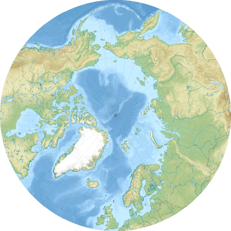
English: Relief location map of the Arctic Ocean.
|
| Data | |
| Fonte | Trabayu propiu |
| Autor | Uwe Dedering |
| Otres versiones |
|

Llicencia
Yo, el titular de los drechos d'autor d'esta obra, la espublizo baxo les siguientes llicencies:
Esti ficheru ta disponible baxo la llicencia Creative Commons Reconocimientu-Compartir igual 3.0 xenérica.
- Ye llibre:
- pa compartir – pa copiar, distribuir y comunicar públicamente la obra
- pa remezclar – p'adautar la obra
- Baxo les condiciones siguientes:
- reconocimientu – Tienes de dar el créitu apropiáu, apurrir un enllaz a la llicencia ya indicar si realizasti dalgún cambéu. Puedes faelo de cualquier mou razonable ,pero non de manera que suxera l'encontu del autor pa ti o pal usu que faigas.
- compartir igual – Si entemeces, tresformes o te bases nesti material, tienes de distribuir les tos contribuciones baxo la mesma llicencia o una compatible cola orixinal.

|
Autorízase la copia, distribución y/o cambéu d'esti documentu baxo los términos de la Llicencia de documentación llibre GNU, versión 1.2 o cualesquier otra que nel futuru espublice la Free Software Foundation; ensin seiciones invariables, testos de portada, nin testos de contraportada. S'inclúi una copia de la llicencia na seición titulada GNU Free Documentation License. |
Pues seleicionar la llicencia que prefieras.
Historial del ficheru
Calca nuna fecha/hora pa ver el ficheru como taba daquella.
| Data/Hora | Miniatura | Dimensiones | Usuariu | Comentariu | |
|---|---|---|---|---|---|
| actual | 08:49 24 avi 2010 | | 1181 × 1181 (2,19 MB) | Uwe Dedering | {{Information |Description={{en|1= Relief location map of the Arctic Ocean. * Projection: Azimuthal equidistant projection. * Area of interest: :* N: 90.0° N :* S: 50.0° N :* W: -180.0° E :* E: 180.0° E * Projection center: :* NS: 90° N :* WE: 0° E |
Usu del ficheru
Les páxines siguientes usen esti ficheru:
Usu global del ficheru
Estes otres wikis usen esti ficheru:
- Usu en ar.wikipedia.org
- Usu en az.wikipedia.org
- Usu en ban.wikipedia.org
- Usu en be-tarask.wikipedia.org
- Usu en ceb.wikipedia.org
- Usu en ce.wikipedia.org
- Usu en cs.wikipedia.org
- Usu en de.wikipedia.org
- Usu en dsb.wikipedia.org
- Usu en en.wikipedia.org
- Kara Sea
- White Sea
- Ilulissat
- East Siberian Sea
- Kursk submarine disaster
- Lincoln Sea
- ATOW1996
- Jan Mayensfield
- Litke Deep
- Pechora Sea
- Molloy Deep
- Prince Gustaf Adolf Sea
- 83-42
- Module:Location map/data/Arctic/doc
- User:Dino/sandbox
- Greenland Plain
- York Mountains
- Iversenfjellet
- Keilhaufjellet
- Lake North Pole
- Hovtinden
- Bohlinryggen
- Systemafjellet
Ver más usos globales d'esti ficheru.