
Ficheru:Amazon-river-NASA.jpg

Tamañu d'esta previsualización: 600 × 600 pixels. Otres resoluciones: 240 × 240 pixels | 480 × 480 pixels | 768 × 768 pixels | 1024 × 1024 pixels | 2048 × 2048 pixels | 4096 × 4096 pixels.
Ficheru orixinal (4096 × 4096 píxels, tamañu de ficheru: 2,79 MB, triba MIME: image/jpeg)
Resume
| Descripción |
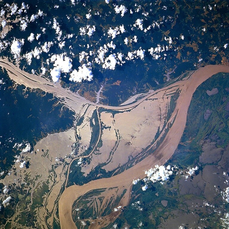
Afrikaans: STS078-751-094 Oorstroomde Amasonerivieroewers in westelike Pará-provinsie, Brasilië in Junie 1996. Die ligging is sowat halfpad tussen Manaus en die Amasonerivierdelta.
Hierdie beeld toon oorstroomde oewers van 'n klein segment van die Amasonerivier, insluitend die oerwouddorpies Oriximiná en Óbidos. Songlans op die modderige rivierwater fasiliteer die onderskeiding van land en water. Deur hierdie beeld met 'n gedetailleerde gebiedskaart te vergelyk, word dit duidelik dat die Amazonerivier sy oewers in die laagliggende dele aanliggend aan die vloedvlakte van die hoofkanaal oorstroom, en groot dele suid van die hoofkanaal staan ook onder (skoon) water. Ontbosde gebiede is binne die digbegroeide terrein aan die noordekant van die Amasonerivier waarneembaar. Die hoofkanaal van die Trombetasrivier kan suidooswaarts nagespeur word, van die linkerrand van die prent af, totdat die Trombetas tussen die oerwouddorpies Oriximiná en Óbidos met die Amasone saamvloei. English: A satellite image of a part of the Amazon River.
Esperanto: La bildo estas kopiita de wikipedia:en. La originala priskribo estas
English: Original caption: [altered to reflect rotation]
|
| Data | |
| Fonte | http://earth.jsc.nasa.gov/sseop/EFS/photoinfo.pl?PHOTO=STS078-751-94 (file) |
| Autor | NASA |
| Ubicación del objeto | | Ubicación de esta y otras imágenes en: OpenStreetMap |
|---|
Este archivo fue catalogado por un de los centros de la Administración Nacional de Aeronáutica y del Espacio (NASA) de los Estados Unidos de Américabajo el identificador de foto: STS078-751-94. Esta etiqueta no indica el estado de los derechos de autor del trabajo adjunto. Se requiere una etiqueta de derechos de autor normal. Para más información vea Commons:Sobre las licencias. Otros idiomas:
|
Llicencia
| Este archivo es de dominio público porque fue creado por la NASA. Las políticas sobre copyright de la NASA estipulan que «el material de la NASA no está protegido con copyright a menos que se indique lo contrario». (Políticas sobre copyright de la NASA o Políticas sobre la utilización de imágenes del Jet Propulsion Laboratory). | ||
 |
Advertencias:
|
Old file history
Transferred from English-Wikipedia:
| date/time | username | edit summary |
|---|---|---|
| 02:26, 6 January 2005 | en:User:Quadell | (tagged) |
| 18:08, 18 June 2004 | en:User:Sverdrup | (Image info) |
| 18:06, 18 June 2004 | en:User:Sverdrup | (A satellite image of a part of the <a href="/wiki/Amazon_River" title="Amazon River">Amazon River</a>) |
| Annotations | This image is annotated: View the annotations at Commons |
Historial del ficheru
Calca nuna fecha/hora pa ver el ficheru como taba daquella.
| Data/Hora | Miniatura | Dimensiones | Usuariu | Comentariu | |
|---|---|---|---|---|---|
| actual | 17:13 8 avi 2022 | | 4096 × 4096 (2,79 MB) | JMK | boost saturation, add some contrast |
| 17:10 8 avi 2022 |  | 4096 × 4096 (2,69 MB) | JMK | rotate 180, north up | |
| 10:10 10 pay 2022 |  | 4096 × 4096 (15,22 MB) | Askeuhd | Higher resolution version | |
| 14:15 10 och 2012 |  | 640 × 640 (418 kB) | Rotatebot | Bot: Image rotated by 180° | |
| 14:39 29 xin 2006 |  | 640 × 640 (377 kB) | Maksim | La bildo estas kopiita de wikipedia:en. La originala priskribo estas: A satellite image of a part of the Amazon River. {{PD-USGov-NASA}} '''Original caption:''' :''STS078-751-094 Amazon River, Western Para Province, Brazil June 1996'' :''This image s |
Usu del ficheru
La páxina siguiente usa esti ficheru:
Usu global del ficheru
Estes otres wikis usen esti ficheru:
- Usu en ar.wikipedia.org
- Usu en azb.wikipedia.org
- Usu en ca.wikipedia.org
- Usu en ce.wikipedia.org
- Usu en cv.wikipedia.org
- Usu en en.wikipedia.org
- Usu en eo.wikipedia.org
- Usu en es.wikipedia.org
- Usu en eu.wikipedia.org
- Usu en fa.wikipedia.org
- Usu en fr.wikipedia.org
- Usu en fy.wikipedia.org
- Usu en id.wikipedia.org
- Usu en ilo.wikipedia.org
- Usu en kk.wikipedia.org
- Usu en krc.wikipedia.org
- Usu en ml.wikipedia.org
- Usu en mr.wikipedia.org
- Usu en nl.wikipedia.org
- Usu en no.wikipedia.org
- Usu en os.wikipedia.org
- Usu en pl.wiktionary.org
- Usu en pt.wikipedia.org
- Usu en rm.wikipedia.org
- Usu en ru.wikipedia.org
- Usu en uk.wikipedia.org
- Usu en vec.wikipedia.org
- Usu en vi.wikipedia.org
- Usu en www.wikidata.org
- Usu en zh-yue.wikipedia.org
- Usu en zh.wikipedia.org