
Ficheru:2010 Haiti earthquake USGS map.png
Nun ta disponible con mayor resolución.
2010_Haiti_earthquake_USGS_map.png (411 × 455 píxels, tamañu de ficheru: 30 kB, triba MIME: image/png)
Resume
| Descripción |
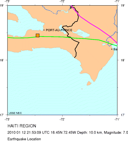
English: Location of the 2010 Haiti earthquake |
| Data | |
| Fonte | USGS - [1] |
| Autor | USGS |
Llicencia
Esta imagen está en el dominio público, ya que contiene materiales que originalmente vinieron del Servicio Geológico de los Estados Unidos de América, una agencia del Departamento del Interior. Para obtener más información, consulte la política oficial de derechos de los USGS.
|
Rexistru de xubíes orixinal
| Data/Hora | Dimensiones | Usuariu | Comentariu |
|---|---|---|---|
| 13 de xineru de 2010, 01:41:06 | 411 × 455 (24797 bytes) | Bsimmons666 (alderique · contribuciones) | {{Information |Description={{en|1=Location of the 2010 Haiti earthquake}} |Source=USGS - [http://neic.usgs.gov/neis/bulletin/neic_rja6_l.html] |Author=USGS |Date=January 12, 2010 |Permission= |other_versions= }} [[Category:Earthquakes of 2010]] |
Historial del ficheru
Calca nuna fecha/hora pa ver el ficheru como taba daquella.
| Data/Hora | Miniatura | Dimensiones | Usuariu | Comentariu | |
|---|---|---|---|---|---|
| actual | 10:06 21 xnt 2014 | | 411 × 455 (30 kB) | GifTagger | Bot: Converting file to superior PNG file. (Source: 2010_Haiti_earthquake_USGS_map.gif). This GIF was problematic due to transparency and non-greyscale color table. |
Usu del ficheru
La páxina siguiente usa esti ficheru:
Usu global del ficheru
Estes otres wikis usen esti ficheru:
- Usu en de.wikipedia.org
- Usu en es.wikipedia.org
- Usu en no.wikipedia.org