
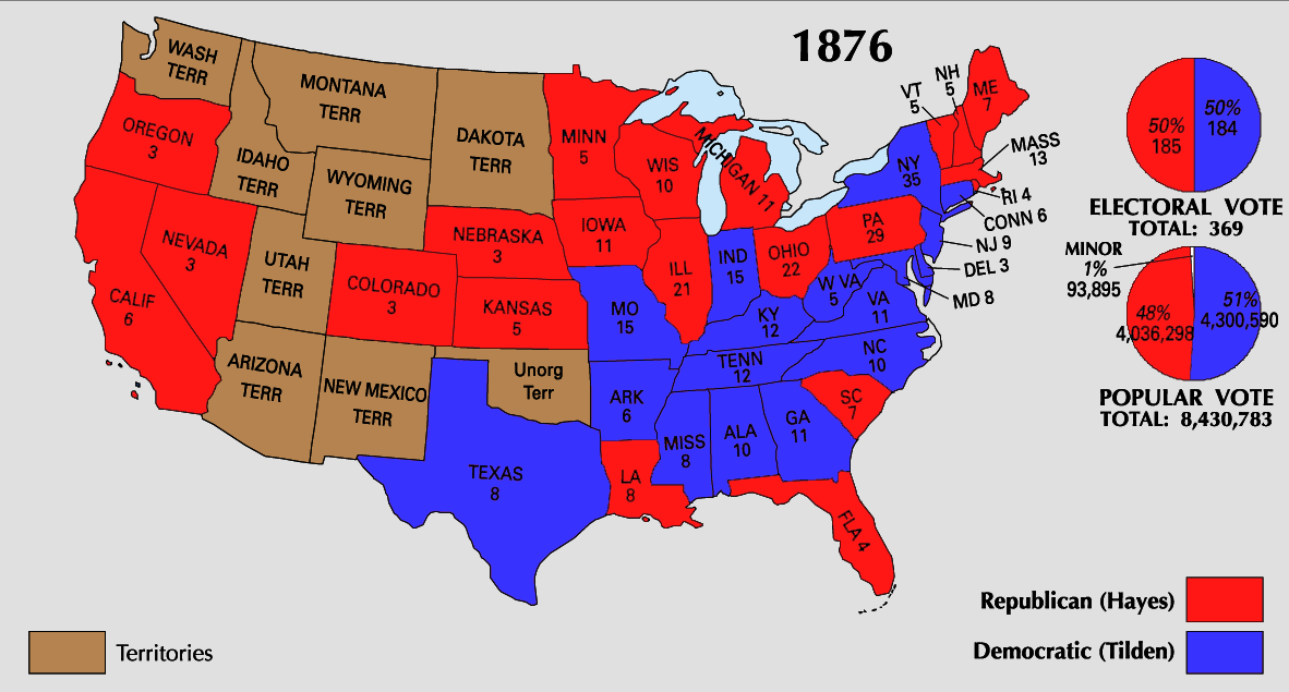
Ficheru:1876 Electoral Map.png
Tamañu d'esta previsualización: 800 × 430 pixels. Otres resoluciones: 320 × 172 pixels | 640 × 344 pixels | 1182 × 635 pixels.
Ficheru orixinal (1182 × 635 píxels, tamañu de ficheru: 177 kB, triba MIME: image/png)
| U.S. presidential election maps from the National Atlas of the United States |
| See also: SVG maps |
| 1789 · 1792 · 1796 · 1800 · 1804 · 1808 · 1812 · 1816 · 1820 · 1824 · 1828 · 1832 · 1836 · 1840 · 1844 · 1848 · 1852 · 1856 · 1860 · 1864 · 1868 · 1872 · 1876 · 1880 · 1884 · 1888 · 1892 · 1896 · 1900 · 1904 · 1908 · 1912 · 1916 · 1920 · 1924 · 1928 · 1932 · 1936 · 1940 · 1944 · 1948 · 1952 · 1956 · 1960 · 1964 · 1968 · 1972 · 1976 · 1980 · 1984 · 1988 · 1992 · 1996 · 2000 · 2004 |
Resume
| Descripción | |
| Fonte | https://nationalmap.gov/small_scale/printable/elections.html |
| Autor | US Geological Survey |
Llicencia
This map was obtained from an edition of the National Atlas of the United States. Like almost all works of the U.S. federal government, works from the National Atlas are in the public domain in the United States.
Online access: NationalAtlas.gov | 1970 print edition: Library of Congress, Perry-Castañeda Library
|
Historial del ficheru
Calca nuna fecha/hora pa ver el ficheru como taba daquella.
| Data/Hora | Miniatura | Dimensiones | Usuariu | Comentariu | |
|---|---|---|---|---|---|
| actual | 23:36 25 xun 2008 | | 1182 × 635 (177 kB) | Tallicfan20 | |
| 23:36 25 xun 2008 |  | 1182 × 635 (155 kB) | Tallicfan20 | better | |
| 04:18 25 may 2008 |  | 1182 × 635 (155 kB) | Tallicfan20 | {{PD-USGov-Atlas}} better quality |
Usu del ficheru
La páxina siguiente usa esti ficheru:
Usu global del ficheru
Estes otres wikis usen esti ficheru:
- Usu en ca.wikipedia.org
- Usu en en.wikipedia.org
- Usu en es.wikipedia.org
- Usu en it.wikipedia.org
- Usu en no.wikipedia.org
- Usu en sv.wikipedia.org
- Usu en uk.wikipedia.org
- Usu en vi.wikipedia.org