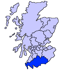
Dumfries and Galloway
| Dumfries and Galloway | |||
|---|---|---|---|
 | |||
| |||
| Alministración | |||
| País | |||
| Nación constitutiva | |||
| ISO 3166-2 | GB-DGY | ||
| Tipu d'entidá | conceyu d'Escocia | ||
| Capital | Dumfries | ||
| Xeografía | |||
| Coordenaes | 55°04′12″N 3°36′11″W / 55.07°N 3.603°O | ||
 | |||
| Superficie | 6426.8845 km² | ||
| Llenda con |
South Lanarkshire (es) | ||
| Demografía | |||
| Población | 148 860 hab. (2019) | ||
| Densidá | 23,16 hab/km² | ||
| Más información | |||
| Fundación | 1975 | ||
| dumgal.gov.uk | |||
Dumfries and Galloway (en gaélicu escocés: Dùn Phris agus an Gall-Ghaidhealaibh) ye un conceyu al sur d'Escocia (Reinu Xuníu).[1][2] Llenda col condáu de Cumbria n'Inglaterra y colos conceyos de South Ayrshire, East Ayrshire, South Lanarkshire y Scottish Borders. Atopar al norte del Fiordu de Solway y al oeste llenda col Mar d'Irlanda.
Referencies[editar | editar la fonte]
- ↑ Office for National Statistics. «United Kingdom: Counties and Unitary Authorities» (inglés). Consultáu'l 24 de febreru de 2013.
- ↑ Office for National Statistics. «Counties, Non-metropolitan Districts and Unitary Authorities» (inglés). Consultáu'l 24 de febreru de 2013.

