
Ficheru:Satellite image of Madagascar in September 2003.jpg
Tamañu d'esta previsualización: 312 × 598 pixels. Otres resoluciones: 125 × 240 pixels | 250 × 480 pixels | 400 × 768 pixels | 534 × 1024 pixels | 1068 × 2048 pixels | 3214 × 6164 pixels.
Ficheru orixinal (3214 × 6164 píxels, tamañu de ficheru: 2,94 MB, triba MIME: image/jpeg)
| Descripción |
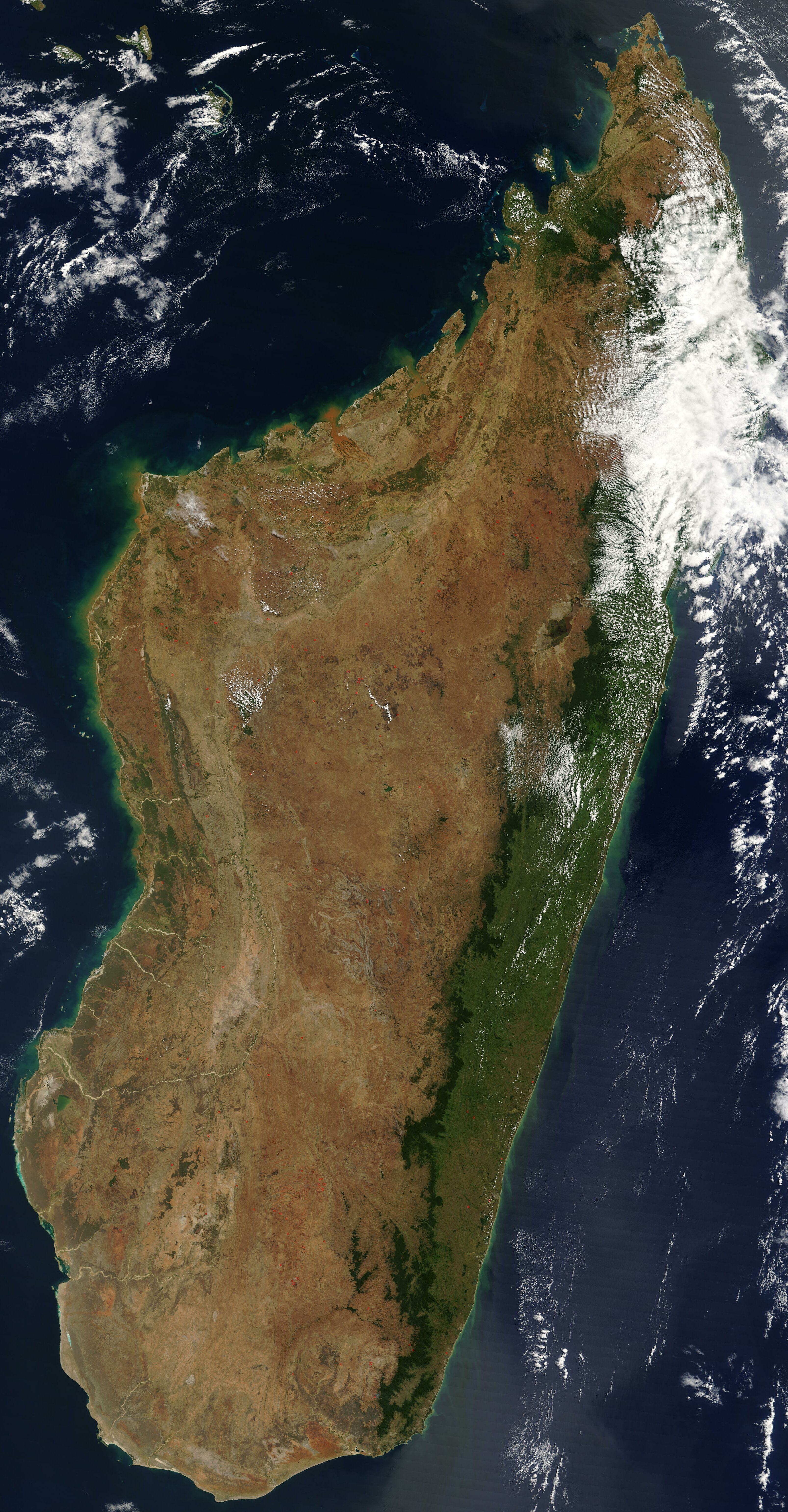
English: Satellite image of Madagascar in September 2003. Slightly cropped, original taken from NASA's Visible Earth: [1]. Original description:
|
| Data | |
| Fonte | http://visibleearth.nasa.gov/view_rec.php?id=5769 |
| Autor | Desconocido |
Esta imagen ha sido seleccionada como la Imagen del día el 1 de noviembre de 2005. Fue descrita como sigue: Español: Imagen satelital de Madagascar en septiembre Otros idiomas:
Čeština: Pohled ze satelitu na Madagaskar (září 2003) Cymraeg: Delwedd lloeren o Madagascar (Medi 2003) Deutsch: Satellitenbild von Madagaskar English: Satellite image of Madagascar in September Español: Imagen satelital de Madagascar en septiembre Français : Image satellite de Madagascar (septembre 2003) Gaeilge: Radharc Madagascar ó spás. Italiano: Immagine satellitare dell'isola di Madagascar Latina: Madagascariae imago satellitia Nederlands: Sattellietfoto van Madagaskar in september. Norsk bokmål: Satellittbilde av Madagaskar. Norsk nynorsk: Satellittbilde av Madagaskar. Polski: Satelitarny obraz Madagaskaru (wrzesień 2003) Slovenčina: Satelitná snímka Madagaskaru (spetember 2003) Suomi: Syyskuinen Madagaskar satelliittikuvassa Svenska: Satellitbild av Madagaskar. Русский: Спутниковая фотография Мадагаскара, четвёртого по величине острова в мире, сделанная 10 сентября 2003 года. ไทย: ภาพถ่ายดาวเทียมเกาะมาดากัสการ์เมื่อเดือนกันยายน พ.ศ. ๒๕๔๖ 中文: 2003年9月马达加斯加的卫星照片 |
| Este archivo es de dominio público porque fue creado por la NASA. Las políticas sobre copyright de la NASA estipulan que «el material de la NASA no está protegido con copyright a menos que se indique lo contrario». (Políticas sobre copyright de la NASA o Políticas sobre la utilización de imágenes del Jet Propulsion Laboratory). | ||
 |
Advertencias:
|
Historial del ficheru
Calca nuna fecha/hora pa ver el ficheru como taba daquella.
| Data/Hora | Miniatura | Dimensiones | Usuariu | Comentariu | |
|---|---|---|---|---|---|
| actual | 12:51 7 xin 2005 | | 3214 × 6164 (2,94 MB) | Hautala | {{PD-USGov-NASA}} Satellite image of Madagascar in September 2003. Slightly cropped, original taken from NASA's Visible Earth http://visibleearth.nasa.gov/cgi-bin/viewrecord?25841 . Original description: The world’s fourth largest island, Madagasca |
Usu del ficheru
Les páxines siguientes usen esti ficheru:
Usu global del ficheru
Estes otres wikis usen esti ficheru:
- Usu en af.wikipedia.org
- Usu en arz.wikipedia.org
- Usu en az.wikipedia.org
- Usu en ba.wikipedia.org
- Usu en be-tarask.wikipedia.org
- Usu en br.wikipedia.org
- Usu en ca.wikipedia.org
- Usu en ce.wikipedia.org
- Usu en ckb.wikipedia.org
- Usu en cs.wikipedia.org
- Usu en cv.wikipedia.org
- Usu en cy.wikipedia.org
- Usu en dag.wikipedia.org
- Usu en da.wikipedia.org
- Usu en de.wikivoyage.org
- Usu en diq.wikipedia.org
- Usu en en.wikipedia.org
- Usu en eo.wikipedia.org
- Usu en eo.wiktionary.org
- Usu en es.wikipedia.org
- Usu en et.wikipedia.org
- Usu en fa.wikipedia.org
- Usu en fi.wikipedia.org
- Usu en fi.wiktionary.org
- Usu en fr.wikipedia.org
- Usu en fr.wikivoyage.org
- Usu en ga.wikipedia.org
- Usu en gl.wikipedia.org
- Usu en gpe.wikipedia.org
- Usu en ha.wikipedia.org
- Usu en he.wikipedia.org
- Usu en ht.wikipedia.org
- Usu en hy.wikipedia.org
- Usu en ia.wikipedia.org
- Usu en ig.wikipedia.org
Ver más usos globales d'esti ficheru.