
Ficheru:Europe location SCO2.png

Tamañu d'esta previsualización: 800 × 599 pixels. Otres resoluciones: 320 × 240 pixels | 640 × 479 pixels | 1024 × 767 pixels | 1280 × 959 pixels | 1594 × 1194 pixels.
Ficheru orixinal (1594 × 1194 píxels, tamañu de ficheru: 558 kB, triba MIME: image/png)
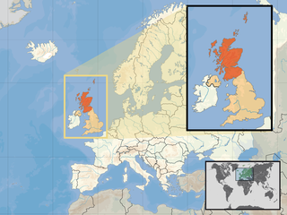
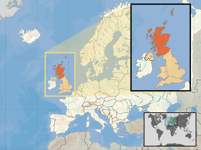
| Descripción | Location of Scotland in the UK and Europe, on terrain map showing surface and underwater contour areas. | |||
| Data | ||||
| Fonte | Derived from Wikimedia Commons image of original work forming part of the "Europe location" map series created by David Liuzzo: derived from Image:Europe_location_SCO.png. | |||
| Autor | uploaded by User:Kmusser (excerpt from User:David_Liuzzo) | |||
| Permisu (Cómo reutilizar esti ficheru) |
|
|||
| Otres versiones |
|


Historial del ficheru
Calca nuna fecha/hora pa ver el ficheru como taba daquella.
| Data/Hora | Miniatura | Dimensiones | Usuariu | Comentariu | |
|---|---|---|---|---|---|
| actual | 12:39 10 abr 2017 | | 1594 × 1194 (558 kB) | Von Sprat | Reverted to version as of 12:25, 27 May 2010 (UTC) |
| 12:39 10 abr 2017 |  | 1600 × 1200 (788 kB) | Von Sprat | greece/turkey border | |
| 12:25 27 may 2010 |  | 1594 × 1194 (558 kB) | Ras67 | cropped | |
| 17:31 29 set 2008 |  | 1600 × 1200 (767 kB) | Kmusser | re-cropped inset to include Shetlands | |
| 17:22 29 set 2008 |  | 1600 × 1200 (807 kB) | Kmusser | {{Information |Description= Location of Scotland in the UK and Europe, on terrain map showing surface and underwater contour areas. |Source=Derived from Wikimedia Commons image of original work forming part of the "Europe location" map series |
Usu del ficheru
Nun hai páxines qu'usen esti ficheru.
Usu global del ficheru
Estes otres wikis usen esti ficheru:
- Usu en als.wikipedia.org
- Usu en an.wikipedia.org
- Usu en az.wiktionary.org
- Usu en ca.wikipedia.org
- Usu en da.wikipedia.org
- Usu en en.wikipedia.org
- Usu en es.wikipedia.org
- Usu en eu.wiktionary.org
- Usu en ext.wikipedia.org
- Usu en fiu-vro.wikipedia.org
- Usu en fr.wikinews.org
- Usu en gag.wikipedia.org
- Usu en gl.wikipedia.org
- Usu en hr.wikipedia.org
- Usu en hr.wikiquote.org
- Usu en kn.wikipedia.org
- Usu en krc.wikipedia.org
- Usu en ml.wikipedia.org
- Usu en mnw.wikipedia.org
- Usu en mr.wikipedia.org
- Usu en my.wikipedia.org
- Usu en nov.wikipedia.org
- Usu en no.wikipedia.org
- Usu en pl.wikipedia.org
- Usu en pl.wikivoyage.org
- Usu en pl.wiktionary.org
- Usu en su.wikipedia.org
- Usu en sv.wikivoyage.org
- Usu en te.wikipedia.org
- Usu en tr.wikipedia.org
- Usu en ug.wikipedia.org
- Usu en vls.wikipedia.org
- Usu en yo.wikipedia.org